ESRI-Urban Planning and Impact Assessment-Module 5 Exercises

This maps shows the occupancy percentage of University Students for Pewter City. Pewter City is a fictitious city developed by the Australia's Queensland State Government, Department of Natural Resources. 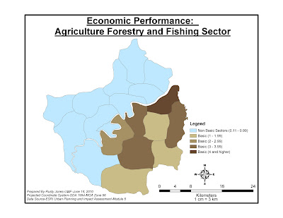

This map shows the Location Quotient (LQ) for the Peltrum Region (fictitious). This in order to understand what industries are driving the economy of a region. This maps shows the LQ for the Agriculture and Fishing Sectors within the Peltrum region and the basic and non-basic sectors.
These exercises where valuable for me in learning about creating queries, template and legend layouts, joins and spatial selections.

No comments:
Post a Comment